Maps are an important tool for understanding the world around us. Whether it’s an unwieldy paper map you struggle to fold up again, a digital map in the palm of your hand, or wayfinding resources plonked around town, they give us visual data that help us conceptualize communities, understand distance and amenities nearby, and centre our mental geography.
It comes as a surprise, then, to discover that according to Google Maps and Google Earth, the Resort Municipality of Whistler is stuck somewhere around the mid-’00s.
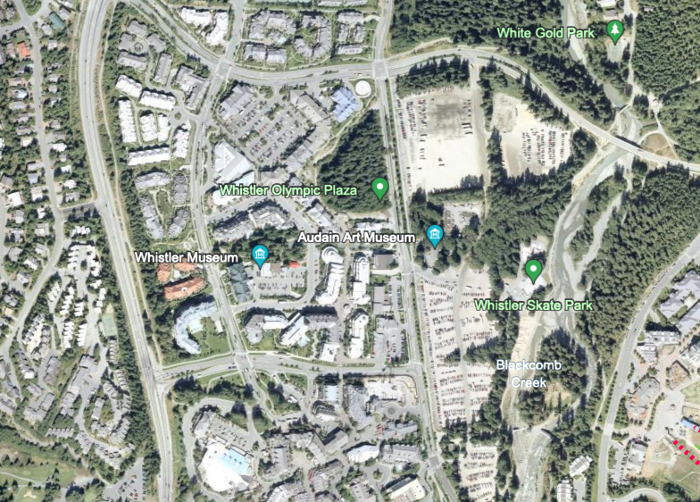
Using data vaguely attributed as being from “2003-recent,” Google Maps satellite imagery shows a Whistler bereft of an Olympic Plaza, Audain Art Museum, 樱桃视频Lil’wat Cultural Centre, or Whistler Public Library.
To the south, Whistler Creekside is dominated by construction, and Cheakamus Crossing is a patch of dirt and a shed, with not a trace of the burgeoning Athletes’ Village to be seen, while to the north, the Rainbow subdivision is a whole lot of trees.
Taken together, Google Maps gives Whistler users the opportunity to engage in a walk down memory lane.
It’s fun to look back in time, but it’s worth asking why—considering Google is one of the largest companies on the planet, with billions of dollars at its disposal, and is the default search engine for almost everyone— it has such a patchy updating schedule for its maps.
Various sources online say Google has a rolling update schedule for its satellite base maps. And you can see it clearly (depending on where you look), so, some parts of the world were last updated for mappage… yesterday.
The updates are not delivered with consistency.
Fernie, B.C. has images from September of this year, while Melbourne, Australia was last captured by Google Maps in 2015. Still, both far more recent than Whistler’s 20-year-old images.
Canadian cartographer Alex McPhee did a little explaining on the ins and outs.
“I remember assuming myself that Google satellite base maps were some kind of real-time view of the Earth,” he said in an email to Pique.
“The truth is much less glamorous. The cost of satellite imagery follows a simple formula: update frequency x resolution. Although tech companies do have billions of dollars, they don’t need up-to-date high-resolution imagery in the same way that the Pentagon needs up-to-date high-resolution imagery.
“So all of the big tech companies give us satellite base maps which prioritize high resolution at the expense of being welded together from a random assortment of years-old sources.”
McPhee pointed to the four big players in mapping as being the go-to destinations to cross-reference base maps: Google, Apple, Microsoft, and Esri.
Esri, or Environmental Systems Research Institute, was noted by McPhee as holding “almost every government mapping software contract in North America.”
Indeed, the Geographic Information System (GIS) mapping software used by our own Resort Municipality of Whistler (RMOW), is Esri.
Of the four, Google stands out as the only mapping software that isn’t even close to being up to date for Whistler when it comes to the base maps. The data is there: Google maps know that the Audain Art Museum is there, that Cheakamus Crossing exists (and has a hostel, too!), they just haven’t gotten around to showing it to you from space yet.
By comparison, Apple Maps, Microsoft’s Bing, and Esri’s data are all up to snuff—at least for Whistler.
Data is hard to come by and harder to compare, but Google declared back in 2015 that its maps were being used by more than a billion users worldwide, while Apple has claimed hundreds of millions of users.
Safe to say, a lot of people use Google maps.
As for the municipality, a communications official told Pique the RMOW’s imagery isn’t from satellites, but airplanes.
“The imagery on our web map is all collected via aircraft; this offers much higher resolution,” they said in an email.
“We aim to collect aerial imagery every two years to ensure they’re as up to date as possible. Some years, as budgets require it, we extend that timeline. In the recent past we’ve commissioned flights in 2009, 2012, 2014, 2018 and 2023.”
So, when could Whistler expect an update of the satellite images? As mentioned, the rolling schedule of updates is on the docket, but queries to Google itself are bounced around to FAQs and explainers that don’t give an answer, likely because there isn’t one. The base maps will be updated when the base maps are updated, and frankly, Google doesn’t need to update them because the vector information (streets, landmarks, etc.) is there in the default map setting—which is where users land when they open the app.
So, until the images Google uses get an update, users wanting a more up-to-date look at Whistler from above have at least three other sources to depend on. Or, you could go straight to some source material with NASA’s Landsat, or the European Space Agency’s Sentinel programs, and trawl some raw data.
“Both services are much lower-resolution than the private providers used by the tech companies, but they have a reliable two-week-ish update frequency for almost everywhere on Earth,” said McPhee.
“Flipping through recent raw data Landsat/Sentinel captures is also a fantastic way to realize just how many satellite images are ruined by clouds—if you’re already annoyed by just the few wisps that make it onto the corporate base maps, you ain’t seen nothing yet!”


